Twin weather disturbance Emong, Dante to intensify Habagat
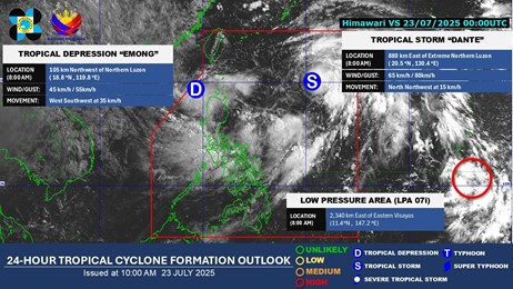
PAGASA said a low pressure area off Luzon’s northern tip developed into tropical depression Emong, Wednesday morning, while cyclone Dante picked up strength.
Dante strengthened into a tropical storm at 8 a.m., PAGASA said.
It was located 900 km east of Extreme Northern Luzon at 10 a.m., packing winds of 65 kilometers per hour and up to 80 kph gusts.
While, Emong was spotted 115 km west northwest of Laoag City, Ilocos Norte. It has sustained winds of 45 kph with gusts up to 55 kph.
Wind signal no. 1 was up in Ilocos Norte, western Ilocos Sur, northwestern La Union, and western Pangasinan.
The highest wind warning possible is wind signal no. 2, PAGASA said.
Moving west southwestward at 35 kph, Emong may into a tropical storm while moving in a looping track over the northern West Philippine Sea due to its interaction with Dante or Fujiwhara effect.
Landfall scenario over Ilocos or Babuyan-Batanes area is possible.
The rain bands of Emong will directly impact Northern Luzon while the rest of Luzon, including Metro Manila, and Western Visayas will be affected by the southwest monsoon enhanced by both Emong and Dante.
Up to torrential rains are expected over Occidental Mindoro, Bataan, Zambales, Pangasinan, and La Union through Friday afternoon.
Serious threats of widespread and life-threatening flooding and landslides remain in these areas.