Stormy weather in Luzon continues; Goring exits PAR in 48 hours
MANILA – Parts of Northern Luzon will experience stormy weather as Typhoon Goring slightly intensified, the weather bureau said Tuesday afternoon.
In its 5 p.m. bulletin, the bureau said Goring packs maximum sustained winds of 165 kph near the center and gustiness of up to 205 kph. The typhoon was last tracked 165 kilometers east of Calayan, Cagayan.
Stormy weather will prevail over Batanes and northeastern Cagayan, including Babuyan Islands, while rains and gusty winds are forecast in Ilocos Norte, Apayao, the rest of mainland Cagayan and Isabela.
Flooding or landslides are possible in those areas due to moderate to heavy rains. Minor to moderate threat to lives and properties due to strong winds, the Philippine Atmospheric, Geophysical and Astronomical Services Administration (PAGASA) said.
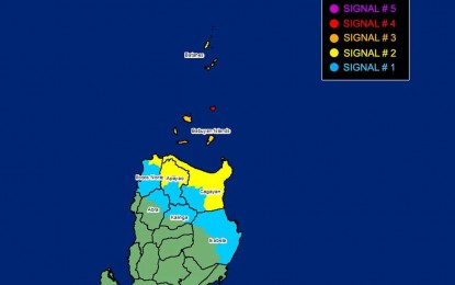
PAGASA said tropical cyclone wind signal (TCWS) No. 3 has been hoisted over the coastal waters of Babuyan Island, while TCWS No. 2 has been hoisted over the northeastern portion of mainland Cagayan (Santa Ana, Gonzaga, Santa Praxedes, Claveria, Sanchez-Mira, Pamplona, Abulug, Ballesteros, Aparri, Buguey, Camalaniugan, Santa Teresita, Allacapan, Lal-Lo, Lasam, Gattaran, Baggao, Peñablanca), the rest of Batanes, the northern portion of Ilocos Norte (Pagudpud, Adams, Bangui, Dumalneg), and the northern portion of Apayao (Calanasan, Luna, Santa Marcela, Flora, Pudtol).
TCWS No. 1 has been hoisted over the northern and eastern portion of Isabela (Dinapigue, San Mariano, Ilagan City, Tumauini, San Pablo, Cabagan, Maconacon, Divilacan, Palanan, Santa Maria, Santo Tomas, Quezon, Delfin Albano), the rest of Ilocos Norte, the rest of Cagayan, the rest of Apayao, northern portion of Abra (Tineg, Lagayan, Lacub, Malibcong) and the northern portion of Kalinga (Balbalan, Pinukpuk, Rizal, City of Tabuk).
The enhanced southwest monsoon will continue to bring gusty conditions over the following areas not under any TCWS, especially in coastal and upland/mountainous areas: Aurora, Bataan, Bulacan, Metro Manila, Calabarzon,
Monsoon rains caused by the southwest monsoon will be experienced over Zambales, Bataan, Occidental Mindoro and northern portion of Palawan.
It will also cause occasional rains over Western Visayas, the rest of Central Luzon, the rest of Mimaropa, Cavite and Batangas. Scattered rain showers and thunderstorms, on the other hand, are forecast in Metro Manila, Zamboanga Peninsula, the rest of Luzon, and the rest of Visayas.
The rest of Mindanao will have isolated rain showers caused by localized thunderstorms.
Meanwhile, rough to very rough seas may be experienced over the seaboards of Luzon, the Visayas, and the northern seaboard of Mindanao.
Goring could exit the Philippine Area of Responsibility either Wednesday night or Thursday. The typhoon may pass very close or make landfall in the vicinity of Babuyan Island between Tuesday night or early Wednesday, PAGASA said. (PNA)