Malacanang welcomes inclusion of WPS on Google Maps
Malacañang welcome with elation the inclusion of the West Philippine Sea (WPS) on Google Maps.
Definitely, this is good news and we are happy about it, Malacanang said in a statement.
It is a welcome development that the West Philippine Sea has been recognized even if there are some who are saying that the West Philippine Sea is just our creation.
The Armed Forces of the Philippines (AFP) had welcomed the inclusion of the West Philippine Sea (WPS) on Google Maps, noting that it affirmed international recognition of the country’s sovereign rights in the region.
As defenders of national sovereignty, the Philippine military sees this as a valuable contribution to truthful representation and public awareness.
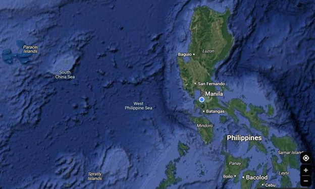
Last week, it was learned that Google Maps has entered WPS in its records.
A Google Maps search on the Scarborough or Panatag Shoal, a common fishing ground which lies within the Philippines’ 200-nautical miles exclusive economic zone, showed it is lying within the body of water identified as WPS.
In 2012, the Philippines, during the administration of former President Benigno Aquino III, officially named areas on the western side of the archipelago as West Philippine Sea.
Administrative Order No. 29, signed on September 5, 2012 declares: “The maritime areas on the western side of the Philippine archipelago are hereby named the West Philippine Sea. These areas include the Luzon Sea as well as the waters around, within and adjacent to the Kalayaan Island Group and Bajo De Masinloc, also known as Scarborough Shoal.”
In 2016, the Permanent Court of Arbitration (PCA) in The Hague ruled in favor of the Philippines over China’s claims in the South China Sea, saying that it had “no legal basis.”
The PCA also ruled that the Ayungin Shoal, the Spratly Islands, Panganiban or Mischief Reef, and Recto or Reed Bank are within the Philippines’ exclusive economic zone.