TS Crising exits PAR; Signal No. 2 raised over 3 Luzon areas
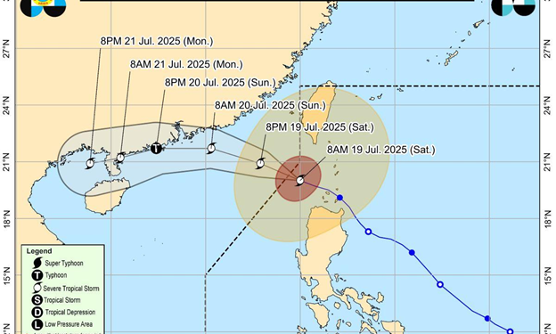
PAGASA said severe tropical storm Crising has exited the Philippine Area of Responsibility
However, the state weather bureau said Tropical Cyclone Wind Signal (TCWS) No. 2 was raised over the following areas in Luzon:
Batanes
the western portion of Babuyan Islands (Dalupiri Is., Calayan Is.)
Ilocos Norte (Burgos, Pasuquin, Pagudpud, Dumalneg, Bangui)
Under TCWS No. 2, winds of greater than 62 km/h and up to 88 km/h may be expected in at least 24 hours.
Further, minor to moderate impacts from gale-force winds are possible within any of the localities where TCWS No. 2 is hoisted, PAGASA said.
TCWS No. 1 meanwhile was raised over the following areas:
the rest of Ilocos Norte
Ilocos Sur
the northern portion La Union (Bangar, Sudipen, Luna, Balaoan, Santol, San Gabriel, Bacnotan, San Juan)
Abra
Apayao
Kalinga
the rest of Cagayan
Under TCWS No. 1, winds of 39-61 km/h may be expected in at least 36 hours or intermittent rains may be expected within 36 hours.
Minimal to minor impacts from strong winds are possible within any of the areas under TCWS No. 1.
Meanwhile, the Southwest Monsoon (Habagat) is expected to bring strong to gale-force gusts over the following areas (especially in coastal and upland areas exposed to winds):
Metro Manila, Central Luzon, CALABARZON, Bicol Region, MIMAROPA, Visayas, Nueva Ecija, Nueva Vizcaya, the rest of Isabela, the rest of La Union, the rest of Benguet, Abra, Zamboanga del Norte, Camiguin, Misamis Oriental, Misamis Occidental, Lanao del Norte, Surigao del Norte, and Dinagat Islands.
PAGASA warned of a minimal to moderate risk of life-threatening storm surge with peak heights reaching 1.0 to 2.0 m within 12 hours over the low-lying or exposed coastal localities of Batanes, Cagayan including Babuyan Islands, Ilocos Norte, and Ilocos Sur.
The center of Crising’s eye was estimated based on all available data 235 km west of Itbayat, Batanes (outside PAR) (20.6 °N, 119.6 °E ).
Moving westward at 15 km/h, the tropical cyclone has a maximum sustained winds of 100 km/h near the center and gustiness of up to 125 km/h.
Crising brought heavy rains, caused flooding and prompted evacuations in many areas overnight. Two people were also reported missing, according to the National Disaster Risk Reduction and Management Council (NDRRMC).
Twenty-six areas were flooded in the country – two in Region 1, three in Mimaropa, two in Region 6, and nineteen in Region 7, according to NDRRMC’s 6 a.m. report. Of these, flooding in two areas were reported receding.
A total of 96,791 individuals or 37,598 families in 417 barangays were affected by Crising. The NDRRMC said 3,556 families or 11,689 individuals were staying in evacuation centers. Meanwhile, 1,781 families or 6,012 individuals stayed outside evacuation centers.
One gate of Binga Dam in Benguet was opened to release water, according to PAGASA.
Parts of Metro Manila also got flooded due to overnight rains from the Southwest Monsoon (Habagat) which was enhanced by Crising.
Classes for Saturday, July 19, 2025 have been suspended in some areas due to the effects of Crising.