19 areas under Signal No. 1 as Crising keeps strength
PAGASA said more areas in Luzon have been placed under Signal No. 1 as Tropical Depression Crising maintained its strength while over the sea east of Aurora.
There are now 19 places under Signal No. 1, up from 14 on Thursday morning.
Batanes
Cagayan including Babuyan Islands
Isabela
Quirino
the northern portion of Nueva Vizcaya (Kasibu, Quezon, Bagabag, Diadi, Bayombong, Solano, Ambaguio, Villaverde, Dupax del Norte, Bambang, Kayapa)
the northern portion of Aurora (Dilasag, Casiguran, Dinalungan, Dipaculao, Baler)
Abra
Apayao
Kalinga
Mountain Province
Ifugao
the northern portion of Benguet (Bakun, Mankayan, Buguias, Kibungan, Kabayan, Bokod, Atok, Kapangan)
Ilocos Norte
Ilocos Sur
the northern portion of La Union (Bangar, Sudipen, Luna, Balaoan, Santol, San Gabriel, Bacnotan)
Polillo Islands
Camarines Norte
the northern portion of Camarines Sur (Caramoan, Garchitorena, Lagonoy, San Jose, Presentacion, Tinambac, Siruma, Goa)
Catanduanes
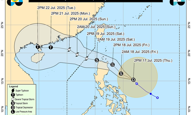
At 4 p.m., Crising was located 335 kilometers northeast of Virac, Catanduanes or 545 km east of Baler, Aurora, moving west northwestward at 30 kilometers per hour.
The tropical depression was packing maximum sustained winds of 55 km/h near the center and gustiness of up to 70 km/h.
“Crising will move generally northwestward over the next 24 hours. A landfall scenario over mainland Cagayan by tomorrow (July 18) evening is possible. Afterwards, it will move westward traversing the northern portion of Northern Luzon, and turn west northwestward until it exits the Philippine Area of Responsibility by Saturday (July 19) afternoon,” PAGASA said.
Crising is expected to develop into a tropical storm on Thursday night or early Friday morning and a severe tropical storm by Saturday morning or afternoon.
”However, further intensification over the Philippine Sea and the possibility of reaching severe tropical storm before landfall is not ruled out,” PAGASA said.
PAGASA said Crising was predicted to cause rains with gusty winds over the Ilocos Region, Cordillera Administrative Region, Cagayan Valley, Aurora, and Catanduanes.
The Southwest Monsoon (Habagat) will bring monsoon rains over Zambales, Bataan, MIMAROPA, Negros Island Region, and Western Visayas, while Metro Manila, Cavite, Laguna, Batangas, Rizal, Central Visayas, Zamboanga Peninsula, Caraga, Northern Mindanao, BARMM, SOCCSKSARGEN, and the rest of Central Luzon will have occasional rains.
The trough of Crising will cause cloudy skies with scattered rains and thunderstorms over Eastern Visayas, Quezon, and the rest of the Bicol Region while partly cloudy to cloudy skies with isolated rain showers or thunderstorms are expected over the rest of Mindanao.
The western sections of Central and Southern Luzon, Visayas, and Mindanao will experience moderate to strong winds with moderate to rough waters.
The Southwest Monsoon will bring strong to gale-force gusts over the following areas:
Thursday: Batangas, Quezon, the rest of Bicol Region, MIMAROPA, Visayas, Zamboanga del Norte, Camiguin, Surigao del Norte, Dinagat Islands, Davao Occidental, Davao Oriental, and Sarangani.
Friday: Bataan, Metro Manila, CALABARZON, Bicol Region, MIMAROPA, Visayas, Zamboanga Peninsula, Basilan, Sulu, Tawi-Tawi, Misamis Occidental, Lanao del Norte, Camiguin, Surigao del Norte, Dinagat Islands, Davao Occidental, and Davao Oriental.
Saturday: Metro Manila, Central Luzon, CALABARZON, MIMAROPA, Bicol Region, Visayas, Zamboanga Peninsula, Misamis Occidental, Lanao Del Norte, Camiguin, Dinagat Islands, Davao Occidental, and Davao Oriental.